
Port Elizabeth Map captures the geographical location of the city. It as well indicates the locations of other important parts of the South African port.
This South Africa’s fifth largest city is known by many names. These names include “Algoa bay”, “The Windy City”, “The Friendly City”, and “Nelson Mandela Bay”. It is sometimes simply referred to as PE.
Port Elizabeth map provides details on one of the largest seaports in South Africa. As a result of important places like Port Elizabeth, Durban, Cape Town, and Johannesburg, the country has been able to build and sustained a large tourist attraction status.
Port Elizabeth Map
-

Port Elizabeth Tourist Map
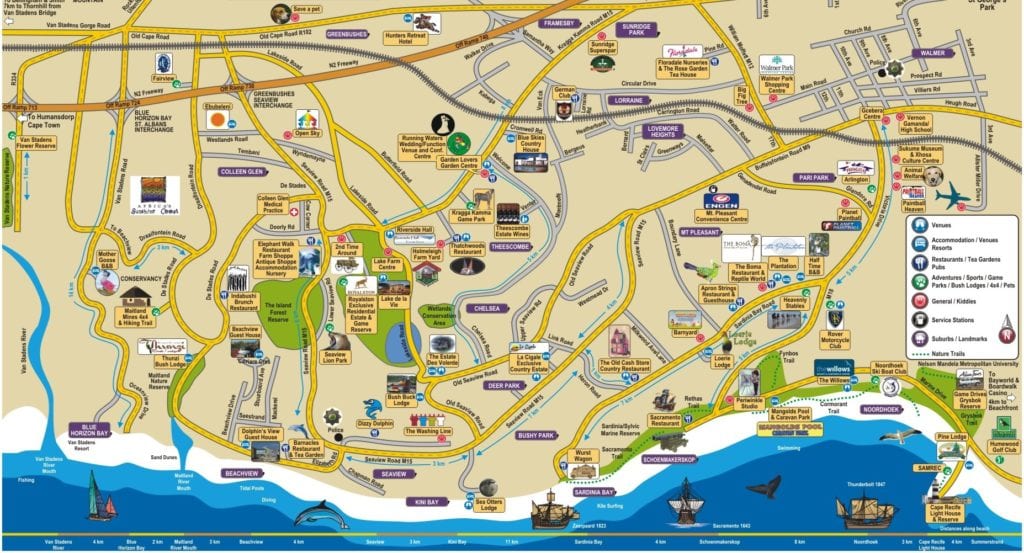
On the map of South Africa, Port Elizabeth Map can be seen lying in the most southern part of the country. The port sleeps in the colony of the Eastern Cape, between Cape Town and Durban. From this part of South Africa, one can easily access four other provinces of the country (Western Cape, Northern Cape, Free State and KwaZulu-Natal), as well as Lesotho.
Port Elizabeth is the largest city in the Eastern Cape Province, with a population of between 1.3 and 1.6 million.
The port is at 763 km east of Cape Town, which is one of the country’s major towns. It is also called the gateway to Eastern Cape Province.
Port Elizabeth map shows a port that is located on the shores of the Indian Ocean. It runs 16km along the Algoa Bay. The map shows major places including Bethelsdorp, Kwazakhele, New Brighton, Newton Park, City Centre and Walmer. It also shows other places including Salt Lake and Swartkops.
The Port Elizabeth airport would as well be seen on a well detailed Port Elizabeth map. Accommodation, beaches, and other interesting places would as well be seen.
The roadmap of the port captures the N2 route which begins from Cape Town, through Somerset West, George, to Port Elizabeth, before passing to King William’s Town, then East London. It also shows the start of N10, which moves to Cradock and Middelburg. Other smaller routes through the port can as well be seen on the map.
History of Port Elizabeth
The history of this largest city in the Eastern Cape Province runs back to over a 100 thousand years. The first certain settlers in the region are said to be the Xhosas, who migrated to the region over 200 years ago. The Xhosas came from the North and displaced the earlier inhabitants of the region, who are thought to be the Sans.
In 1488 and 1497, the region got its first Europeans with the visit of Portuguese explorer, Bartholomew Dias, and Vasco Da Gama, respectively. While Dias visited St Croix, Da Gama was near the Bird Island.
Manuel de Mesquita Perestrelo gave the region the name Baia de Lagoa in 1576. The name was coined as a result of the lagoon in the area which is at the mouth of the Baakens River. The name is the root of its current name, Algoa Bay.
Read Also: South African Capitals – Here’s What You Need To Know
It was however until 1801 that Port Elizabeth had its first European settlers, when Dr. Johannes Theodosuis Van Der Kemp, a British missionary was sent to the area. The missionary was to later build a settlement in today’s Bethelsdorp.
By the 1820s, the region had come by its present name, Port Elizabeth. The name was given by the then Acting Governor of the Cape Colony, Sir Rufane Shaw Donkin after his late wife, Elizabeth.
Port Elizabeth got it’s wide cultural base since it became an autonomous municipality in 1861. This was made so by the arrival of various immigrants to join the Europeans and Cape Malay.
Places to Visit in Port Elizabeth
-

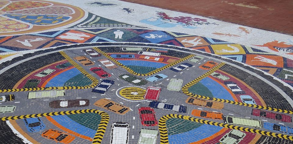
Port Elizabeth: Route 67
Port Elizabeth provides very interesting places one can visit to have a full of the city’s friendliness. Such places include:
- Addo Elephant National Park: This Park is one of the largest national parks in the country. The park has over 600 elephants and around 185 species of birds. It also has rhinos, lions, zebras, and hyenas among other wildlife.
- Route 67: Among the most creative spots in South Africa is Route 67. It collects visual arts, urban design and long-time memories towards weaving a single experience of the present South Africa with its past.
- Red Location Museum: This is an apartheid museum in the port city. It captures events during the apartheid struggle in the country. Located in New Brighton, the museum has an art gallery, exhibition space, restaurant and an auditorium.